The Ballindysert or Rathgormack Formation
 |
| View across the wooded rim of the Formation over the hidden Suir Valley towards Slievenamon. Carrickatobar and Toor Hills are seen centre-right. |
The Ballindysert or Rathgormack Formation
is a low platform, averaging about 150 metres elevation, perched above the Suir
Valley in north Waterford, stretching for over 20 kilometres from a little east of Harney`s Cross in Glenpatrick to Portlaw. The platform can clearly be seen from
Knockanaffrin Ridge, or along the Military Road in Glenpatrick, to the south. Everywhere
the platform is fairly flat, if a little undulating. Near Glenpatrick it is characterised
by a few low hills, most of them wooded e.g. Raven`s Rock, Carrickatobar, Toor
or Carrigcaum. Further east, beyond Ardmore or Windgap, the soil improves, the
elevation drops a little towards Carrick-on-Suir and Portlaw, and there is more
rolling farm land.
The Rim
A particularly striking feature seen along most of the Formation`s length is the rim or steep fall of ground/abrupt break of slope from the platform down towards the Suir Valley to the north. This rim is especially noticeable along the R680 between Carrick-on-Suir and Kilsheelan. It rises quite steeply from the road here in places and its northerly aspect guarantees more shade, frost and snow during cold weather than the sunnier Tipperary side of the river.
 |
| Glenpatrick Picnic Area in the heart of the Glasha Gorge |
The Glasha Gorge
Another striking feature of the Rathgormack
Formation is the number of small gorges that have been cut down through the rim
by relatively small rivers. The Glen Stream near Churchtown and the Aughnabrone
Stream near Millvale have gouged out gorges approximately 500 metres long and up
to 50 metres deep. Undoubtedly however, the most dramatic gorge is that created
by the Glasha Stream in Glenpatrick. The Glasha rises in Moanyarha Bog on the
slopes of Knockanaffrin Ridge. It flows north for about three kilometres, then
east for a further three kilometres before turning back north for its final
three kilometres, joining the Suir a kilometre east of Kilsheelan.
The gorge it has created is located along
the final three-kilometre stretch of its journey, between Carrickatober/Burnt
Rock Hill in Coolishal or Kilsheelan Wood to the west and Toor or Carrigcaum
Hill to the east. It is a most impressive feature, quite steep sided and over a
hundred metres deep for most of its length. It is also however, an almost
incongruous feature. “Glais” means stream and this stream is far too small for
the amazing valley it has created. It begs the question – how was it formed?
One theory suggests that the great melt-water flows at the end of the last ice
age about 10,000 years ago, may have had a significant part to play.
 |
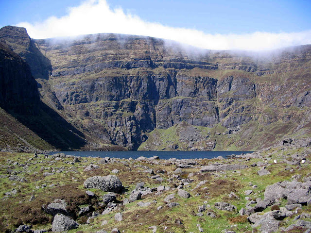
| Ballindysert/Rathgormack Formation platform separating the Devonian Sandstones of the Comeraghs and the Carboniferous Limestones of the Suir Valley |
Geological Origins
To get a better understanding of the
Ballindysert/Rathgormack Formation we need to look at a little geology. Eyes often
start to glaze over when the word geology is mentioned. Time to use the KISS
rule then – keep it simple stupid! Geologists divide time into huge chunks
called eras and shorter chunks called periods. The geology of the Comeraghs and
its environs is associated with four periods from the Primary Era. The oldest
rocks in Waterford, found in the south east, are sedimentary and igneous rocks
laid down during the Ordovician Period over 450 million years ago. The next
period is called the Silurian, dating from 450 to 400 m.y.a. These are the
rocks that floor the Ballindysert Formation. During these two periods Ireland
(in two halves at this stage!) was located in a great ocean called the Iapetus,
in the southern hemisphere. The next period is called the Devonian, dating less
than 400 m.y.a. The vast majority of the rocks on the Comeraghs are either Old
Red Sandstone or Conglomerates and were laid down in the shallow Munster Basin
during this period. At this time Ireland was located about 20 degrees south.
Finally, during the Carboniferous Period from 350 to 300 m.y.a. Ireland lay at
the bottom of a tropical sea on the Equator. Consequently, the main rocks
deposited at this time were limestones. Carboniferous Limestones floor the Suir
Valley.
Between 290 and 270 m.y.a. a great mountain
building event called the Armorican Orogenesis occurred, creating a series of
fold mountains across Munster running from west to east. Over the millennia erosion removed most
of the limestones from the hills, revealing the Old Red Sandstone. Regarding
the Ballindysert/Rathgormack Formation, most of the sandstones were removed here as
well, and a geological window was opened up, revealing ancient Silurian
sedimentary and metamorphic rocks – sandstones, shales, mudstones and slates. So, the Rathgormack Platform is underlain by much older rocks than neigbouring Knockanaffrin Ridge, underlain by Devonian Sandstones, and Suir Valley, underlain by Carboniferous Limestones. Remnants of the Devonian sandstones have been preserved as
caps on the 200 metres-plus high hills that constitute the rim/abrupt break of
slope of the Formation – Carrickatober, Carrigcaum, Windgap etc. And it was
through these sandstone knobs that running water gouged out gorges like the
Glasha in recent geological times.


Comments
Post a Comment