Geography, Geology, Geomorphology, Glaciation
A Little Geography
The Comeraghs stretch from the Suir Valley and Kilsheelan Woods in the north to the Mauma Road in the south, and from Ballymacarbry in the west to Mahon Bridge in the east, and cover an area of almost 200 square kilometres. They are visible from most corners of the county from Clonmel in the north west to Tramore in the south east. The mountains consist of two main ridges - the northern ridge called Knockanaffrin and the southern ridge sometimes called the Monavullagh - separated by the Central Plateau. There are some outlying hills such as Cruachán Déiseach in the south, Cruachán Paorach in the east and Lachtnafrankee in the north-west. The highest point is located on the Central Plateau a little west of Coumshingaun and is simply known as “792”. The range acts as a watershed for the surrounding catchment areas of the Suir Valley to the north and the Waterford coastal plains to the south, with the main streams being the Glenary and Clodiagh draining into the Suir, while the Colligan, Dalligan, Tay and Mahon flow south to the sea. |
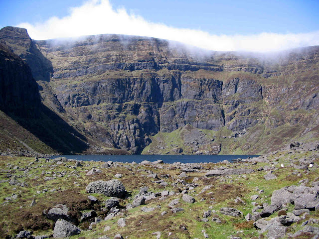
| Sandstone Conglomerates on Coumshingaun backwall |
A Little Geology
Four geological periods are relevant for pretty much all of Waterford`s geology. The Ordovician Period from about 500 to 440 million years ago (mya) saw two underwater volcanoes create the volcanic rocks such as rhyolite and andesite that can be seen along the Copper Coast today.During the early Silurian Period from 440 to 420 mya plate tectonics closed the Iapetus Ocean. Up to that time the north-western half of “Ireland” was on one continental plate while the south-eastern part was on another. When the plates collided, as well as joining the two halves of Ireland, a great “orogenesis” or mountain building event occurred, creating fold mountains with a south-west to north-east trend – the Caledonian Orogenesis. These are not really seen east of a line between Limerick and Dundalk but the Comeraghs, like the Blackstairs and the Wicklows, do display signs of being influenced by the event.
The late Devonian Period from about 380 to 360 mya is of interest because this was the time when the most common rock in Waterford, the sedimentary rock, old red sandstone, was laid down. At that time Ireland was located at about 30 degrees south and experienced a hot desert climate. This rock can be seen today in thick conglomerate and finer sandstone beds in the cliff faces of the Comeragh coums.
Finally, during the early Carboniferous Period from 350 to 320 mya Ireland was located on the Equator and was covered by a shallow tropical sea. Consequentially, a lot of carboniferous limestone was created, seen today along the Suir Valley, the Dungarvan Syncline and around Ardmore.
 |
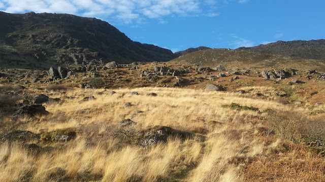
| Monavullagh Ridge runs south to north - Caledonian Orogenesis influence |
A Little Geomorphology
Geomorphology is the science which studies how natural processes such as folding, faulting, vulcanicity, plate tectonics, earthquakes, erosion, deposition etc. affect the evolution of the landscape, profoundly changing the shape and configuration of the earth`s landforms over time. Geomorphologically, the three main features of the Comeraghs are the Knockanaffrin and Monavullagh Ridges sandwiching between them the Comeragh Plateau. Geomorphologists tell us that most of the mountains in Munster (from Dungarvan to Dingle) are Armorican or Variscan or Hercynian in age. This essentially means that they were pushed up as great east-west running fold mountains during another mountain building event, the Armorican Orogenesis, around 300 mya at the end of the Carboniferous Period. Interestingly, both the Monavullagh and Knockannafrin Ridges have a more north to south trend, hinting perhaps that their framework like that of the Blackstairs and Wicklow Mountains was laid down a lot further back, during the Caledonian Orogenesis over 400 mya.So, folding seems to be the major process
involved in the creation of the Comeraghs. Faulting has also played a part. Geomorphologists
tell us that the Mauma Road lies on an east-west fault between the Monavullagh
Ridge and Croughaun Déiseach while the R676 sits on a north-south fault between
Coumshingaun and Croughaun Paorach. There is little evidence of vulcanicity on
the Comeraghs apart from Curraduff Cliff above Coolnahorna Wood, about 1.5
kilometres east of Crotty`s Rock. The rock here is believed to have formed from
volcanic lavas from the late Devonian Period.
 |
| Lip Moraine and Erratics at Coumduala |
A Little Glaciation
Without doubt the most influential natural or physical process shaping our landscape in recent geological times has been glaciation. In his scholarly tome “Reading the Irish Landscape” Frank Mitchell informs us that there may have been up to 25 ice ages in the last 2 million years! The two most “recent” of these were the Munsterian Glaciation from 300,000 to 130,000 years ago, and the Midlandian Glaciation from 75,000 to 13,000 years ago. For huge chunks of time glaciers of varying sizes shaped and re-shaped the land, creating spectacular erosional and depositional landforms such as corries, aretes, hanging valleys, moraines, erratics, eskers, drumlins etc. In the Comeraghs the great coums such as Coumshingaun and Crotty`s and glacial valleys such as the Mahon and the Nire were formed. The last cold phase to affect the earth occurred between about 12,000 and 10,000 years ago and is known as the Nahanagan Stadial in Ireland after lake Nahanagan in Wicklow. Small glaciers came back to the Comeraghs reshaping the coums once again.For more detail on the geology and geomorphology of the Comeraghs peruse “A Guide to the Comeragh Mountains” by Declan McGrath and “Corries, Caves and Coast” by Matthew Parkes, Robert Meehan and Sophie Preteseille.


Comments
Post a Comment