Posts

Showing posts from September, 2021
Image
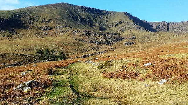
 A Special Comeragh Place - Ned Curran`s Path leading into Ned`s with Coumtay on the right What and Where is Ned Curran`s? Situated in the beautiful cradle of the south-western Comeraghs, Ned Curran`s has a most idyllic location on the banks of the Tay in the jaws of the coum of the same name. Coumtay is Coum Mahon`s westerly neighbour. But Ned`s is about much more than scenery. Abandoned just three generations ago, Ned`s is one of the most evocative mountain ruins you will ever visit. One visit is all it takes to understand why. A Scenic Walk to Ned`s from Mahon Falls Mahon Falls car park is a good spot from which to start an out-and-back walk to Ned`s. From the car park follow the meandering road uphill in a southerly direction for about 500 metres to a sheep grid. The scenery is spectacular here. In the distance is Helvic Head while the Monavullagh Ridge is directly ahead. Dry Coum Éag is the hole in the ridge on the left, the dip in the ridge is Bearna an Mhadra saddle or col, w
Image
 Coumaraglin with its Bronze Age Monuments Fulacht Fia in the Upper Araglin Valley Where is Coumaraglin? Coumaraglin is situated close to the small village of Kilbrien in the south-western Comeraghs. Specifically, it is the broad bowl-shaped valley that sits to the west of the southern ridge of the Comeraghs (the Monavullagh Ridge) that sweeps south from Seefin to the Mauma Road. The Araglin River, a tributary of the Colligan, rises on the southern slopes of Seefin and drains the northern part of the valley, creating a small gorge in the process, while the much smaller Monavar drains the southern part. Between the two lies the archaeologically significant Cnoicín, literally little hill. Archaeology in Waterford Archaeologists believe that settlement in county Waterford goes back 7000 years to the  late Mesolithic (Middle Stone Age). The Sites and Monuments Record (S.M.R) for the county was issued in 1988 with over 1200 sites identified dating pre 1700. A team of field archaeologist