Comeragh Glacial Features
Outside of Kerry and Wicklow, the Comeraghs is one of the most spectacularly glaciated areas in Ireland. The nine square kilometre area of the Central Comeragh Plateau is encircled by no less than nine coums. Surely this makes it one of the most glaciated pieces of real estate in Ireland! Here is some information on some of the glacial features to be found on our local mountains.
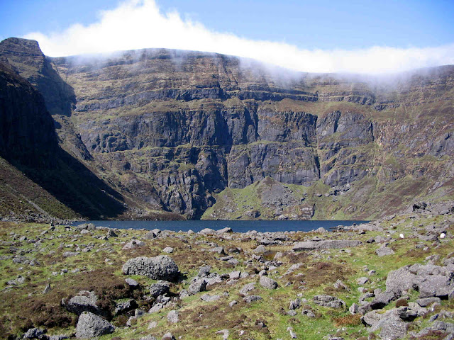
 |
| Dramatic View down to Coumduala from Knockanaffrin Ridge |
A Coum (“com” in Irish, “corrie” or “coire” in Scots` Gaelic, “cirque” in French and “cwm” in Welsh) is the birth place of a mountain glacier (a river of ice).
How old are the Comeragh coums?
Hard to be definitive but, according to Frank Mitchell, one of Ireland`s leading authorities on glaciation, most of the ice sculpting was done between about 300,000 and 130,000 years ago with some reshaping in more recent times.
How many coums in the Comeraghs?
Debatable but there are at least 14. Here goes: Lough Mohra, Lough Coumduala, Crotty`s, Coumshingaun, Fáscoum or Kilclooney, Coum Mahon, Coumtay, Coum Knockaun, Coum Éag, Coumfea, The Coumalochas, The Sgilloges, Coumlara and Coum Iarthar or The Boolas.
How many have lakes?
Nine. Mohra, Coumduala, Crotty`s, Coumshingaun, Coumtay, Coumfea, The Coumalochas, The Sgilloges and The Boolas.
What is the most spectacular coum?
Many believe it is Coumshingaun. It is considered to be one of the finest examples of a classic armchair or bowl-shaped glacial hollow in Britain or Ireland. It`s backwall drops a sheer 400 metres, well over 1200 feet, and it`s lake measures in excess of 35 acres.
What is the longest coum?
Probably Coum Iarthar or the Boolas. It measures over 1 km from the “lip” moraine at the mouth to the cliff wall at the back.
What is the largest coum?
The Coumalochas, one of the feeder-coums at the head of the Nire Valley. Measured from behind the “lip” to the bottom of the cliffs all around, it is over 1 sq. km. in area.
What is the highest lake?
The innermost of the four Boolas, at almost 550 metres above sea level.
 |
| Arete between Coumshingaun and Fáscoum (hidden) |
What is an”arête”?
A French word, it is a narrow knife-edged ridge between two coums. There is a very good example between Coumshingaun and Fáscoum. What is a “moraine”?
Another French word. Basically, a moraine is a low ridge of unsorted glacial debris, mainly large boulders, left by moving and melting glaciers. Many lateral (running along the side of the coums), transverse (running across), and end (the lip at the mouth of the coum that often ponds in the lake) moraines can be found in the Comeraghs.
What is a “tarn”?
Essentially tarns are the lakes that occupy some coums. The name comes from “tjorn”, a Viking/Norse word meaning “tear shaped”. They vary in size, for example Coumshingaun is a tarn but so too are the six or seven small ponds/lakes in Coumtay.
 |
| Coumtay Tarns |
What is an “erratic?”
A large boulder transported by a glacier. Sometimes they occur in large numbers - a boulder train - down slope from a coum, as at Fáscoum. (From the French word “errare” to wander).
What is a “u-shaped valley”?
The straight, steep sided, flat floored valley through which a large glacier travelled slowly over a long period of time. The Nire and Mahon valleys are considered good examples.
What is a “hanging valley”?
A valley left high above the main glaciated valley, probably occupied by a glacier but by a much smaller one than that of the main valley. The Comeraghs don`t have any hanging valleys, the inner coum above the main coum in Crotty`s is the nearest thing. What is a “col”?
A dip in a ridge, often called a saddle or gap because of its shape. Glacial erosion and frost action may have helped to lower ridges at narrow points. A col often indicates the path melt water took at the time of glacial melting. “The Gap” between the Nire and Rathgormack is a good example, as is “Bealach an Mháma” or the Mauma road between Crohaun and the Monavullagh Ridge.
 |
| Ribbon Lakes in the Boolas |
What are “ribbon lakes”?
Often called “pater noster” or “rock basin” lakes or “loganna”. A “Log” means a hollow in Irish and these lakes were created in glacial valleys by a combination of glacial plucking to create the hollow and morainic deposition to impound the water. There are often a number of lakes laced together by a stream, and in some valleys, there may be a noticeable drop in elevation from the innermost to the outermost lake, hence the term “glacial staircase”. The Boolas is the only Comeragh example.
What is a”nunatak” or “pyramidal peak”?
A mountain top that stood above the level of the glacier. Also called “Matterhorn peak”. Nunataks may also have been created when the high ground between a few adjacent coums was sharpened and steepened. Stookeenmeen near Coumshingaun and especially Knockanaffrin are good Comeragh examples.


Comments
Post a Comment