Knockanaffrin Ridge
 |
| View from the Mass Rock north across Coolishal Wood to Slievenamon |
The Mass Rock
The name Knockanaffrin means the hill of the mass – “Cnoc an Aifrinn”, reminding us today of penal times when Catholics were persecuted for practising their religion. The name can be seen on documents relating to the Cromwellian Settlement of 1654, a full 50 years before the systematic introduction of the various penal laws. There is what is believed to be an authentic mass rock near Carrigsheegowna on the ridge`s north-eastern slopes. On high ground near the crest of the ridge, the mass rock`s location would have afforded good views towards both Nire and Suir Valleys, thus giving worshippers time to disperse before the arrival of the “red coats” from Clonmel.
The Seven Sisters
Knockanaffrin is also known today as the “Seven Sisters”, a reference perhaps to the rocky prominences which jut up from the ridgeline. Shauneenbréaga, Carrigsheegowna, Knocksheegowna (with its Trig Pillar) and Knockanaffrin itself are the main ones but there are other un-named ones. This aspect of the ridge`s character is especially noticeable from the Clonmel side.
 |
| The Seven Sisters from Harney`s Cross |
Geomorphology
Geomorphologically, the three main features of the Comeraghs are the Knockanaffrin and Monavullagh Ridges sandwiching between them the Comeragh Plateau. Knockanaffrin Ridge stretches from Harney`s Cross in the north to the Gap in the south. It measures about 8 kilometres in length and its highest point is Knockanaffrin itself, at 755 metres. This was known as "Carraig an tSaighdiúra" in the past, a reference no doubt to the soldiers who frequented the ridge during the Ordnance Survey in the 1840s.
Geomorphologists tell us that most of the mountains in Munster (from Dungarvan to Dingle) are Armorican or Variscan in age. This essentially means that they were pushed up as great east-west running fold mountains about 270 to 290 million years ago. Interestingly, both the Monavullagh and Knockannafrin ridges have a more north to south trend, hinting perhaps that their framework like that of the Blackstairs and Wicklow Mountains was laid down a lot further back, perhaps during the Caledonian Orogenesis over 400 million years ago.
Geography
Geographically, the ridge separates the Nire and Suir Valleys. As such it acts as a small watershed in north Waterford – the Glenary and Nire flowing west, the Glasha and Clodiagh flowing east.
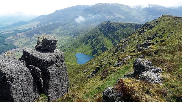
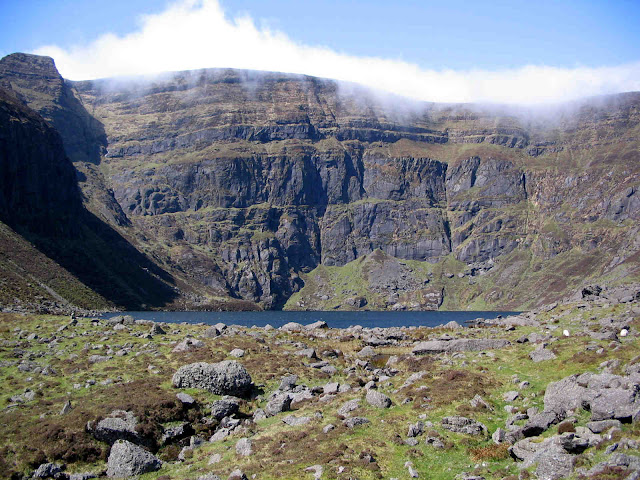
The vagaries of ice action are very obvious on Knockanaffrin Ridge. There is little evidence of glacial scouring on its western flanks yet there are two fine lake-adorned coums on its eastern flanks – Loughs Mohra and Coumduala. Both have the classic features of an ice-scoured hollow or coum – great encircling cliffs and impounding moraines. The colder north-easterly aspect almost certainly guaranteed more lying ice and less melting during the ice ages thus facilitating the creation of the coums on this side of the ridge.
Knockanaffrin itself is one of just two nunataks or pyramidal peaks on the Comeraghs. Its profile from Glenpatrick is very striking, particularly under winter snow. Geomorphologists believe that during recent ice ages the very highest points of the ridge stood up above the ice but were severely sharpened by frost, especially on the north-eastern flanks – hence the term the “Reeks of Glenpatrick” perhaps.
 |
| View from Knockanaffrin Ridge over Coumduala towards Crotty`s Rock and the Comeragh Plateau |


Comments
Post a Comment