The Monavullaghs
 |
| View from Farbréaga south-west across Crohaun to Dungarvan Bay and Helvick Hd |
Where are the Monavullaghs?
The name Monavullaghs comes from “Móin an Mhullaigh” – the turf or bog of the summit. The name interestingly could also have come from "Móin an Bhuaile" which means the turf of the herding place. Some people say that it is just another name for the Comeraghs, as the name was used in the past to refer to the boggy ground on the top of the Comeragh Plateau. Others argue however that the name refers to the south-western Comeraghs. So which is it? Whatever the answer, today the 300 metres wide neck of high ground between the backwalls of the Coumalochas and Coumtay is considered by many to be the frontier between the Comeraghs and Monavullaghs if there is one! Everything west and south of here is considered Monavullagh country.
 |
| Carrigbrack and Milk Hill Ridges with the Colligan Valley in between from near Seefin |
The Northern Monavullaghs
The northern Monavullaghs consist of a few short ridges that snake west towards the Colligan from boggy Leacathimlay above Coumtay - namely Milk Hill to Tooreen Mountain, Carrigbrack, and forested Barracree Mountain. These three small ridges surround the Colligan Valley (from “Coll Logáin” – hazel hollow). The Colligan and its tributary, the Coumduane flow south from here, being joined about 5 kilometres further south by the Araglin. The northern slopes of Milk Hill overlook the Nire Valley and there are some interesting Bronze Age monuments in Tooreen townland.
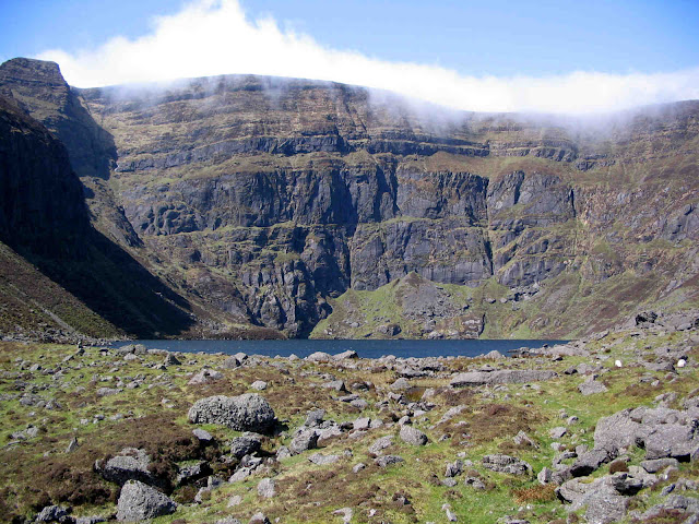
 |
| Looking south along the Monavullagh Ridge - Bearna an Mhadra Col lies ahead, Coumaraglin Mountain rises behind it, while the hole on the left is dry Coum Éag |
The Southern Monavullaghs - the Monavullagh Ridge
The southern Monavullaghs consists mainly of a 6 kilometres long ridge that stretches south from the Comeragh Plateau towards Dungarvan Bay. The ridge essentially stretches from Seefin to the Mauma Road and separates the broad bowl-shaped Coumaraglin (more Bronze Age monuments here) to the west from the rolling farmland of Kilrossanty to the east. Apart from Coumaraglin and dry Coum Éag (which means the hollow of death) dropping steeply to the east from Coumaraglin Mountain, the three main features of the ridge are Seefin, Bearna an Mhadra and Farbréaga.
 |
| Seefin with its modern blockhouse and ancient cairn |
Seefin
Seefin refers to the seat of Fionn Mac Cumhaill of Na Fianna fame and is surely one of the most common place name on Irish mountains. This one stands 726 metres above sea level at the northern end of the Monavullagh Ridge and is the highest point on the Monavullaghs. There is an unsightly concrete hut on the summit erected in 1979 as part of a project to provide multi-channel television for west Waterford. The summit also boasts an impressive Bronze Age cairn and a fallen-over trig pillar, but most impressive of all is the magnificent panorama it affords on a clear day - Knockanaffrin Ridge and the Comeragh Plateau off to the north, the holes and shoulders of Coums Knockaun, Tay and Mahon delineating the Comeragh Plateau to the north-east, the Waterford Coast to the east and the Monavullagh Ridge heading off south towards Dungarvan Bay.
Bearna an Mhadra
This is the name given to the very definite col located on the Monavullagh Ridge almost 2 kilometres south of Seefin. Note the painted standing stone, known locally as the Stone Man, and the circular stone enclosure nearby, almost certainly from early Christian times. Saint Declan, Waterford`s patron saint, seems to have passed this way! According to tradition, Bearna an Mhadra gets its name from a legend about Declan and a certain plate of dog dressed as mutton! It is also claimed that an ancient path, St. Declan`s Path, crossed the gap here linking Kilmac and Kilrossanty with Kilbrien.
Farbréaga
Farbréaga comes from "Fear Bréige" meaning false man, and is another name commonly used on Irish mountains, often referring to a peak at the beginning of a ridge. This one stands at the southern end of the ridge at 593 metres elevation, and boasts a fine cairn and glorious views south over the Mauma Road and Crohaun or Cruachán Déiseach towards Dungarvan Bay and beyond to Helvick Head. The dramatic Coum Éag lies about 300 metres to the north, while about 1.5 kilometres away, its south-eastern slopes is graced by a Holy Year Cross erected by the people of Kilrossanty.


ReplyDeleteVery nice blog post. I like this site. Continue the good work! It is exciting to read it and, use it. Thanks for the article. Feel free to visit my website,you can also love this Names that Mean Mountain Blog.