The Gap and Bóithrín na Sochraide
 |
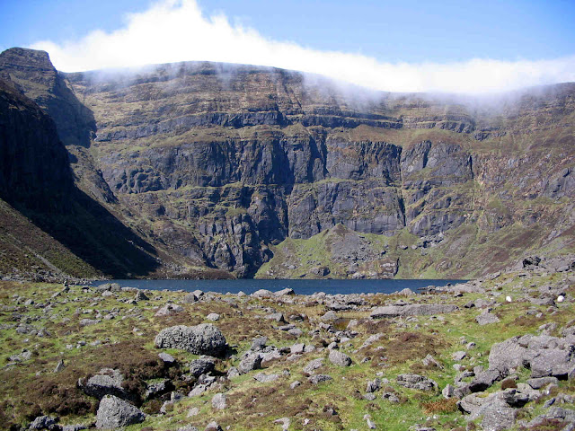
| Looking along Bóithrín na Sochraide towards the Head of the Gap |
The Gap - Glacial Col
At the southern end of Knockanaffrin Ridge lies the Gap – at 466 metres it is the highest pass in county Waterford. It separates the ridge from the Comeragh Plateau. It is without question one of the most recognizable features of the Comeraghs, its “saddle on the horse`s back” profile being easily identified from many corners of the county. In geomorphological jargon (landforms) it is classified as a “col” – a dip in a ridge in a glaciated mountain upland area, usually created by the movement of ice or melt water across the ridge. The steep ground to the east of the Gap has named rock prominences such as “Carraig na Sean Éan” (the hump on the right of the photo) and “Carraig na nGabhar” (a little higher up) jutting out from the Comeragh Plateau.Funeral Paths in Mountainous Areas
The Normans gave us our parishes. In many mountainous areas peripheral parts of a parish were often cut off from the rest by high ground. Consequently, when someone died and needed to be brought to church and buried in consecrated ground, a funeral cortege would accompany the deceased across the mountain. There are a number of these funeral paths in Waterford e.g. from Glendalaghin in the outer Nire through Glenary and on into Clonmel, but undoubtedly the best-known mountain funeral path in the county was the one between the inner Nire and Rathgormack and was known as “Bóithrín na Sochraide”. It was used in the 18th and 19th centuries and probably further back. There was no church or burial ground in the Nire until the mid-19th century and since Knockanaffrin, Glenanore and Carrigeen townlands in the Nire were part of Rathgormack parish, the tradition of the trans-mountain funeral route grew. |
| The Head of the Gap with Path from the Nire crossing to the Rathgormack side |
Features along the Path
The western part of the route is still very discernible on the ground today and is relatively flat in places. There are a couple of boulders where tradition holds the bearers laid the corpse while they rested and these are known as “Clocha na gCorp”. The eastern part of the route on the Rathgormack side is much rockier and is known as “An Staighre” which means the stairs, a word which comes from the Norse word “stegr” meaning a rocky path. An interesting tradition linked with these funerals along mountain paths was “An Tionlacan” which means the accompanying. Many people from Rathgormack would meet the cortege at the Gap and accompany it to the church. Down the centuries the path functioned as a trade route as well as a funerary one. |
| Looking downhill along An Staighre on the Rathgormack side |


Comments
Post a Comment