Comeragh Ridges
A ridge is a long narrow stretch of high ground which for the most part separates river valleys. A spur or a shoulder or a “srón” is a sloping area of high ground which links a valley to a ridge. Sometimes it can be difficult to differentiate a spur/shoulder from a ridge. Where does a spur or a shoulder or a “srón” end and a ridge begin? Is there a minimum length of high ground before the term “ridge” can be invoked? Well, there you have me! At any rate, what most of us landscape lovers can agree on is that ridges often provide glorious walking in good weather because of the relatively dry underfoot conditions and the wide-ranging views usually available from their lofty heights. |
| View from Knockanaffrin summit towards Coumduala and the Comeragh Plateau |
Main Comeragh Ridges
Undoubtedly, the standout ridges on the Comeraghs are Knockanaffrin and Monavullagh. Both have a generally north to south running trend (like the nearby Blackstairs) which sets them apart from the west-east trend of Munster`s Armorican mountains. Evidence perhaps that the Armorican folding of nearly 300 million years ago didn`t quite extend across Munster to the Comeraghs, and that the more ancient 400 million years old Caledonian framework of mainly north to south running ridges was preserved here.Knockanaffrin Ridge
Lying to the north of the Comeragh Plateau, Knockanaffrin Ridge (Cnoc an Aifrinn, the hill of the mass) is about 8 kilometres long and runs from Harney`s Cross to the Gap. Also known as the “Seven Sisters” because of a number of rocky prominences along its length, the ridge`s highest point is Knockanaffrin itself at 755 metres elevation. The ridge separates the Nire Valley from the undulating farmlands of Rathgormack. The vagaries of ice action are clearly to be seen on a trip along its crestline. Its eastern rim is steep and cliff-lined while its western rim is much gentler. While its western wall has no evidence of ice action, its eastern wall is adorned by two fine glacial hollows occupied by lakes, Lough Mohra and Coumduala. Aspect is most certainly the main reason for the differences between the two sides of the ridge – during glacial periods ice hung about on the colder north eastern facing slopes long enough to gouge and scrape and leave its calling card in these cliffs and coums. Knockanaffrin Peak itself is a “nunatak” or pyramidal peak which stood above the level of the ice in glacial times and this dramatic profile is very evident from Glenpatrick Cross.
 |
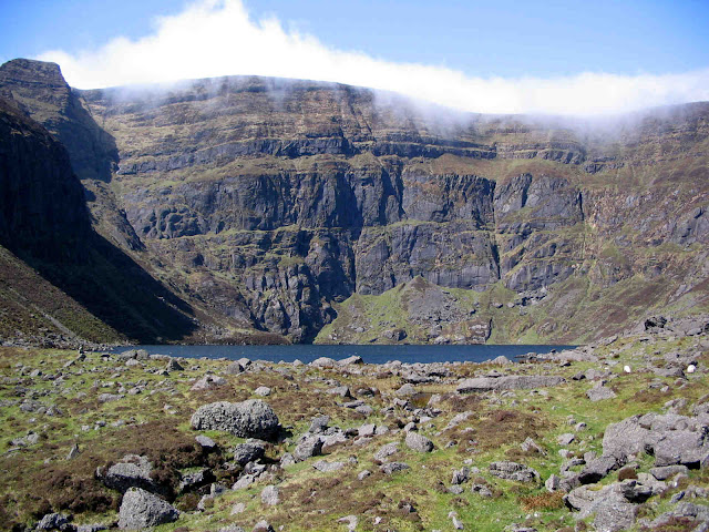
| View south along Monavullagh Ridge with Coum Éag on the left |
Monavullagh Ridge
The Monavullagh Ridge lies to the south of the Comeragh Plateau and is about 6 kilometres long. It runs from the Mauma Road in the south to Seefin in the north, at 726 metres in elevation the ridge`s highest point. It separates the broad bowl-shaped Coumaraglin Valley with its Bronze Age features to the west from the rolling landscape of Killrossanty to the east. A walk south from Seefin along its crestline will bring you past the interesting Bearna an Mhadra Gap with its standing stone and remnants of an early Christian fort, and give you fine views into the north facing dry Coum Éag and further south to Dungarvan Bay.Coumshingaun Arete
An arete is a particularly narrow, steep-sided, and cliff-lined ridge that is created when two mountain glaciers cut back the high ground between them. Spectacular Irish aretes include The Big Gun/Cruach Mór, Carrauntoohil/Beenkeeragh and Gearhane aretes, all in Kerry. In Waterford we have our own grand example, the Coumshingaun Arete, which separates Coumshingaun from its southern neighbour, dry Fáscoum. The arete begins at Muirisín Ryan`s Rock at the south western corner of the coum, rising gradually westward for 1.5 kilometres before topping out eventually on the plateau above. Aretes are exhilarating places with their huge boulders, rocky paths, precipitous slopes and jaw-dropping views. Care is needed when negotiating this arete especially as the narrow winding path makes its way up the imposing rock buttress at its western end. |
| Coumshingaun Arete |
Other Comeragh Ridges
The western Comeraghs have a few short ridges. The Upper Colligan Valley, north-south running Com na gCapall, is flanked by the Blantisour/Milk Hill Ridge to the west and the Milk Hill/Toureen Mountain Ridge to the east. The nearby east-west running Coumduane Valley is flanked by the Carrigbrack Ridge to the north and the heavily wooded Barracree Ridge to the south. Neither of these “coms” has much evidence of glaciation but the ridges mentioned make for pleasant walking around their margins.Another couple of ridges of note are the Lachtnafrankee/Boolabrien and Long Hill Ridges on the north-western corner of the Comeraghs. The former separates the Nire Valley from wooded Glenary; the latter Glenary from the Suir Valley around Clonmel. A long circular walk, starting at the parking area near the unusual Carey`s Castle on the Glenary River, will introduce you to both of these ridges. Features of interest include the aforementioned “castle”, Glenary clochán or cluster-village and the Holy Cross on Long Hill.
And so, to finish
There are a number of high shoulders on the Comeraghs which may constitute ridges. Two of these that are worth mentioning encircle gorgeous Coum Mahon. To the west the Davmore/Davbeg shoulder, a southern extension of Comeragh Mountain, separates Coum Mahon from Coum Tay. To the east the strangely named “Scurras” is a tortuous, rock pinnacled, almost arete-like shoulder which cuts off Coum Mahon from the lowlands north of Mahon Bridge. (the name may originate from “Scor”, an Irish word meaning rock pinnacle). Discover the Comeragh ridges and enjoy.


Comments
Post a Comment