The Comeragh Old Red Sandstone Plateau
 |
| 792 - Highest Point on the Plateau - Looking towards Knockanaffrin and Slievenamon |
A Real Plateau
One significant difference between the Comeraghs and other Munster mountain ranges is that the Comeraghs possess a plateau. Munster`s mountains from “Dungarvan to Dingle” are classified by geomorphologists as Armorican or Variscan – this essentially means that they were created as great east-west running fold systems between 270 and 300 million years ago. However, few of these mountain ranges have any large plateaux. The Galtees and Knockmealdowns don`t. Ditto the Nagles, Boggeraghs, Derrynasaggarts, Mullaghareirks, Ballyhouras. Even in Kerry, apart from around Mangerton perhaps, there are no great areas of plateau to be found on the McGillycuddy`s Reeks, the Brandon Range, the Slieve Mish etc. Like the Kingdom, Cork has many hills, humpy bumpy ridges and rocky mountains, but few areas of high plateau – the lake strewn area of Glaslough Mountain in the Cahas possibly, but here the average elevation is only about 450 metres.
The Comeraghs have in fact a truer plateau profile than most mountainous area in the country, displaying those two defining characteristics of a plateau – flattish rolling topography at a high elevation and encircling steep cliffs. The Comeragh Plateau is in fact of national importance, being the best example of a high-level Old Red Sandstone Plateau in Ireland.
The Nature of the Plateau
Botanically the Plateau has a Montane habitat. This essentially means that it possesses a very limited flora of plants that can survive in high winds, heavy rain and low temperatures – not unexpected in an undulating area of humps and hollows at an elevation of over 700 metres. Sedges are common up here e.g. deergrass and common cottongrass. Hardy lichens are found amongst the boulders around the tops of the coums, while hardy flowering plants such as Saint Patrick`s Cabbage are also commonly seen.
Of course, all that moisture means plenty mosses. At one time there was extensive blanket bog on the Plateau but much of it has been eroded down to the underlying bedrock e.g. at the back of the Boolas. The ubiquitous peat haggs are a constant reminder of the ongoing erosion of the surface peat. Names like “Móin an Mhullaigh” (which means the turf on the top) and “The Black Bog” pretty much tells us what the nature of the surface of the Plateau is – away from the deergrass and cottongrass there be bog-holes and peat haggs!
 |
| Looking along the arete from the south-west corner of Coumshingaun |
Plateau Geography
The plateau isn`t level, there is an elevation range of about 150 metres – from 650 to almost 800 metres. In area it measures about 8 or 9 square kilometres. It separates the two main Comeragh ridges, Knockanaffrin and Monavullagh, from each other. The Gap col marks it`s northern boundary while the narrow strip of peat-hagged mountain between the Coumalochas and Coumtay marks its southern one.
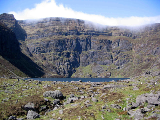
One of the most interesting aspects of the Comeragh Plateau is that it is ringed by corries or coums. In the past small valley glaciers developed in hollows right around this upland area leaving it today as one of Ireland`s most precious glacial landscapes. Ten dramatic coums, six of them with sizeable lakes, encircle the plateau. Let`s name them starting from the north-west - Coumfea, Coumalocha, Sgilloges, Coumlara, Boolas, Crotty`s. Coumshingaun, Fáscoum, Coummahon and Coumtay.
The Comeragh Plateau is central Waterford`s dominant watershed. The Nire and Clodiagh rivers flow northward to the Suir while the Colligan, Tay and Mahon flow southward to the sea. The headwaters of the Mahon reach like tentacles into the heart of the plateau, creating a small intermontane basin between the plateau`s peaks above the Nire Valley to the west and 792 and Knockaunapeebra to the east. The aforementioned 792 is of course the highest point on the Comeraghs and is just 400 metres away from the dramatic backwall of Coumshingaun, Ireland`s finest coum. A circular 6 hour walk on a clear day around the rim of the Central Comeragh Plateau gazing down into each of its ten coums by turn is truly one of Ireland`s best walks.
 |
| View across the Plateau towards the Monavullaghs and beyond to Helvick Head |
Favourite Plateau Locations
A plateau can be a cold, wind-swept, rain-lashed God forsaken place. But, clifftops (and there are many on the Comeraghs) offer fantastic vistas on fair weather days, especially in the summer half of the year. There are many locations on the Comeragh Plateau well worth a visit because of the panoramic views they offer, and some even provide a modicum of shelter from which to enjoy the scene and the cuppa!
1. The south-west corner of Coumshingaun – there is a glorious view along the Coumshingaun Arete from here and the peat haggs provide the shelter.
2. Crotty`s Rock – Great shelter here amongst the huge fault-blocks, and a grand view down to Crotty`s Lake, its moraines so colourfully-bedecked with purple heather in late summer.
3. Top of Mahon Falls – not much shelter here but the scene below you stretching along the length of the Mahon Valley is truly magnificent.
4. Back of the Sgilloges at the Seanbhean Waterfall – this is a great lunch spot. But be aware – you may get an unexpected shower from the spray from the waterfall if the wind is from the north-west!
5. Back of the Coumalochas – no shelter here unfortunately but you have a grand view down into the Coumalochas, the largest of the Nire coums. Also, if you walk south for about 300 metres you will be rewarded with a vista stretching south across Coumtay to the Monavullaghs and beyond to Helvick Head.
 |
| Looking down the Mahon Valley from the top of Mahon Falls |


Comments
Post a Comment