 |
| The Boolas Pater Noster/Ribbon Lakes from the Comeragh Plateau |
A Special Comeragh Place – The Boolas
There is no doubt that we humans have special places that affect us in indefinable ways. As Nicholas Crane puts it in his book “The making of the British Landscape” - “We have a predisposition to invest locations with attachments”. Why do we become attached to certain places? Now there`s a sixty-four-thousand-dollar question! Do these places fire our imagination or lift our spirit? Do they help us accept if not understand our place in the cosmos?Howsoever it works, we seem to have a need as humans to switch off from the treadmill of modern life and visit our special places to experience the tranquility and pleasure they give us. It is not surprising to my mind that many of these special places are found in mountains. Mountains have a sense of timelessness and permanence about them that make us all too aware of our own mortality. They seem to speak to our souls and draw us back time after time. As a lover of the Comeraghs, the Boolas is one of my special places.
 |
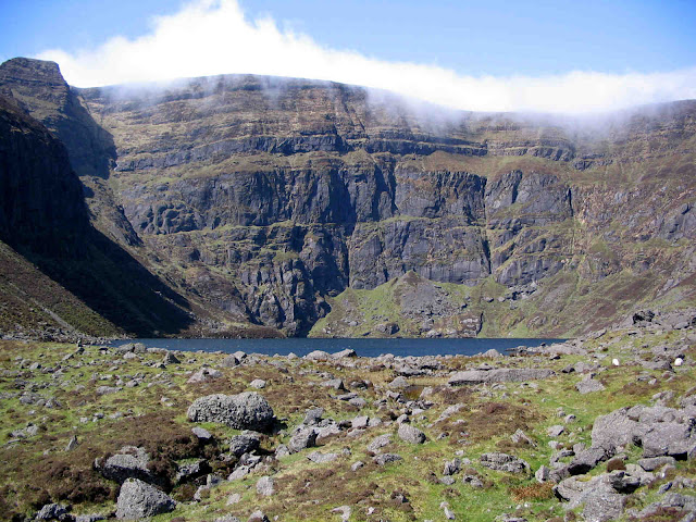
| Outermost Boola with moraine blocking inner coum behind |
What are The Boolas?
The Boolas (Coum Iarthar on O.S. maps) is, at 1km in length, the longest coum in the Comeraghs. It houses four ribbon or “pater noster” lakes, the innermost one being the highest lake in Waterford at almost 550 metres. These lakes are sited at ever decreasing elevations from backwall to impounding frontal moraine and so the Boolas is one of the best examples outside of Kerry of a “glacial staircase”. The Boolas is flanked on one side by Crotty`s Lake, another coum, and on the other by the Gap, a glacial col or saddle. Frank Mitchell in his book “Reading the Irish Landscape” explains how ice created these spectacular landscape features.
How to get there
Drive to Rathgormack near Carrick-on-Suir and from the village go west along the R678 for 3km to Clondonnell Cross. Turn left (south) here and travel for another 3 km to a sharp right-angled bend at Curraheen. Parking is available in an old farmyard 50 metres up the boreen. Grid Ref S 306 154. |
| Bottom of the Gap path with Boolas looming ahead |
Way Marked Walk
There is a way marked walk to the Boolas so you can follow the way markers all the way to the coum. Curraheen is a very pleasant approach to the Comeraghs so the outward journey is almost as special as the destination itself. Off you go along an old boreen for about 300 metres. Cross a stile, a couple of fields, another stile, one more field until you reach the open mountain after about 15 minutes. Drink in the views as the dramatic Knockanaffrin Ridge draws you on. The dip in the ridge on the left is the Gap. A large moraine (ridge of unsorted rock waste and boulder clay deposited by ice) obscures most of the Boolas coum at this stage.Now turn left or south. Cross a couple of streams and when you reach the corner of Graigavalla forest, keep the trees on your left and you soon pass a huge boulder on your right. You are now standing at a very interesting historic if not pre-historic spot! This boulder, according to archaeologists, is located at a possible Bronze Age cairn field site. It also marks the bottom of the ancient “Bóithrín na Sochraide” funeral path across the Gap from the Nire. Ahead, Crotty`s Rock and the large chasm of the Boolas loom large. Continue along the edge of the wood until you reach the Douglas stream.
Turn right now and, keeping the water on your left, ascend for about 1km into the coum. When you reach the first lake (pond really) the marked walk veers right. You may wish to follow sheep tracks across the moraine to explore the inner coum to eventually reach the highest lake in Waterford. When ready, retrace your steps to the outermost lake and follow the way marked route for a kilometre or so to the head of the Gap and from there turn right (north-east) and proceed downhill along Bóithrín na Sochraide” until you meet the huge boulder you passed on your way up. Turn left and follow the markers back to the start.
 |
| Innermost Boola - highest lake in Waterford |
A special place
What`s so special about the Boolas? It`s
just one of the fourteen glacial coums on the Comeraghs. It`s not as big as nor
does it have as large a lake as Coumshingaun. It`s vista is not as dramatic
from a distance as say Mahon Falls. Yet… there`s something about it that draws
me back again and again. Maybe it`s the fact that you rarely meet other people here.
Maybe it`s the peace and sense of timelessness you feel when you rest on the
bank of the innermost lake. Maybe it`s the variety of hump and hollow, of lake
and moraine. Maybe it`s the stark brooding beauty of the place under winter
snow. These coums are nature`s wondrous cathedrals and for me nowhere in the
Comeraghs do I get this sense of awe at nature`s majesty as much as I get it in
the heart of the Boolas.


Comments
Post a Comment